Wegenkaarten - Oceanië
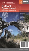 Wegenkaart - landkaart Explorer Map Outback Queensland | Hema Maps
Outback Queensland Map (4th edition - now on Waterproof Paper) Outback Queensland (QLD) contains mapping and visitor information for one of the most iconic regions in Australia. Mapping at a …
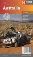 Wegenkaart - landkaart Australia - Australië | Hema Maps
Mooie, grote, duidelijke kaart van Australië met veel informatie. Oa bezinestations (ook in de outback) en een goed overzicht van de doorgaande (grote) wegen waardoor de kaart erg handig is …
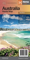 Wegenkaart - landkaart Australia - Australië | Hema Maps
Een handzame kaart van Australië met op de achterkant een aantal stadsplattegrondjes. A country map of Australia that includes city maps on the reverse for compact travel use. …
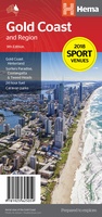 Wegenkaart - landkaart Gold Coast and region | Hema Maps
Goede, overzichtelijke, leesbare kaart van de hele provincie. Nationale Parken zijn er goed op te vinden en de afstanden worden weergegeven. Op de achterkant nog deelkaartjes van enkele steden en …
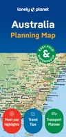 Wegenkaart - landkaart Planning Map Australia - Australië | Lonely Planet
Durable and waterproof, with a handy slipcase and an easy-fold format, Lonely Planet Australia Planning Map is your conveniently-sized passport to traveling with ease. Get more from your map and …
★★★★★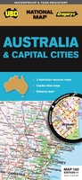 Wegenkaart - landkaart 180 Australia & Capital Cities | UBD Gregory's
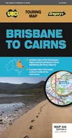 Wegenkaart - landkaart 444 Brisbane to Cairns NP | UBD Gregory's
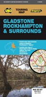 Wegenkaart - landkaart 483/487 Gladstone Rockhampton & Surrounds | UBD Gregory's
 Wegenkaart - landkaart 283/298 Southern Highlands & South Coast NSW | UBD Gregory's
 Wegenkaart - landkaart 284 Wagga Wagga & Riverina | UBD Gregory's
 Wegenkaart - landkaart Great Desert Tracks West | Australië | Hema Maps
 Wegenkaart - landkaart Great Desert Tracks East | Australië | Hema Maps
 Wegenkaart - landkaart Great Desert Tracks Centraal |Australië | Hema Maps
 Wegenkaart - landkaart 308 Great Ocean Road | UBD Gregory's
 Wegenkaart - landkaart 419 Queensland State & Cities | UBD Gregory's
 Wegenkaart - landkaart 382 Ballarat Grampians & Spa Country | UBD Gregory's
 Wegenkaart - landkaart 385 Geelong Suburban Streets | UBD Gregory's
 Wegenkaart - landkaart 405 Sunshine Coast | UBD Gregory's
 Wegenkaart - landkaart 319 Victoria State & Cities | UBD Gregory's
 Wegenkaart - landkaart 381 Albury / Wodonga / Murray River & High country | UBD Gregory's
Laatste reviews

De landkaart voldoet geheel aan mijn wensen. Ik zocht en zo klein mogelijke schaal, om onze routes te plannen. Helaas is de eerste bestelling verdwenen …
★★★★★ door Albert Huizing 04 januari 2025 | Heeft dit artikel gekocht
Prachtige foto’s die herkenbaar zijn na een bezoek aan Suriname. Interessante achtergrond informatie. Jammer dat het boek niet meer gedrukt wordt. Snel verstuurd!
★★★★★ door Neeltje 03 januari 2025 | Heeft dit artikel gekocht
Ik kocht dit boek voor pakjesavond voor mijn zwager en schoonzus, die het heerlijk vinden om regelmatig samen te wandelen, ergens in Nederland. Ook houden …
★★★★★ door Cindy de Lange-Wirds 03 januari 2025 | Heeft dit artikel gekocht
O.a. en kaart van Curaçao besteld. Prachtig van kwaliteit maar wel wat jammer dat de uitvoering wat gedateerd is. Reisgids is prima, evenals het fietsboekje …
★★★★★ door Henk van den Born 03 januari 2025 | Heeft dit artikel gekocht