Categorieën
-
Boeken
- Aanwijswoordenboeken
- Accommodatiegidsen
- Atlassen
- Bed and Breakfast Gidsen
- Bergsporthandboeken
- Campergidsen
- Camperhandboeken
- Campinggidsen
- Duikgidsen
- Fietsatlassen
- Fietsgidsen
- Fotoboeken
- Historische Atlassen
- Kanogidsen
- Kinderatlassen
- Kinderreisgidsen
- Kleurboeken
- Klimgids - Klettersteiggidsen
- Klimgids - Klimtopo
- Kookboeken
- Mountainbikegidsen
- Natuurgidsen
- Pelgrimsroutes
- Reisboeken
- Reisdagboeken
- Reisfotografiegidsen
- Reisgidsen
- Reishandboeken
- Reisinspiratieboeken
- Reisverhalen
- Sneeuwschoenwandelgidsen
- Survivalgidsen
- Tourskigidsen
- Treinreisgidsen
- Vaargidsen
- Vogelgidsen
-
Wandelgidsen
- Afrika
- Azië
-
Europa
- Albanië
- Andorra
- Armenië
- België
- Bosnië - Hercegovina
- Bulgarije
- Cyprus
- Denemarken
- Duitsland
-
Engeland
- Noord Engeland
- North East England
- ♦ Northumberland National Park
- Yorkshire and the Humber
- ♦ Yorkshire Dales Nationaal Park
- ♦ North York Moors Nationaal Park
- ■ York
- North West England
- ♦ Cumbria
- ♦ Isle of Man
- ♦ Lake District Nationaal Park
- ♦ North Pennines AONB
- ■ Liverpool
- ■ Manchester
- 🥾 Hadrian's Wall Path
- East Midlands
- West Midlands
- ♦ Peak District Nationaal Park
- ■ Birmingham
- Wales
- Swansea and the Gower
- ♦ Pembrokeshire Coast National Park
- ♦ Snowdonia Nationaal Park
- ♦ Brecon Beacons Nationaal Park
- East of England - East Anglia
- ♦ The Broads National Park
- South West England
- Cornwall
- Devon
- Dorset
- ■ Bath
- ♦ Cotswolds AONB
- ♦ Devon - Cornwall
- 🥾 South West Coast Path
- ♦ New Forrest National Park
- ♦ Exmoor National Park
- ♦ Dartmoor National Park
- ■ Bristol
- South East England
- ♦ Kent
- ♦ South Downs Nationaal Park
- ♦ Isle of Wight
- ■ Londen
- ■ Oxford
- Kanaaleilanden
- ♦ Guernsey
- ♦ Jersey
- Meer steden
- Estland
- Faroer
- Finland
- Frankrijk
- Georgië
- Griekenland
- Groenland
- Hongarije
- IJsland
- Ierland
- Italië
- Kosovo
- Kroatië
- Letland
- Liechtenstein
- Litouwen
- Luxemburg
- Malta
- Montenegro
- Nederland
- Noord-Ierland
- Noord-Macedonië
- Noorwegen
- Oostenrijk
- Polen
- Portugal
- Roemenië
- Scandinavië
- Schotland
- Servië
- Slovenië
- Slowakije
- Spanje
- Tsjechië
- Turkije
- Zweden
- Zwitserland
- Midden-Amerika
- Midden-Oosten
- Noord-Amerika
- Oceanië
- Wereld
- Zuid-Amerika
- Watersport handboeken
- Werken en wonen in buitenland
- Woordenboeken & Taalgidsen
- Kaarten
- Opruiming
- Puzzels
- Travel Gadgets
- Wandkaarten
- Wereldbollen
Veilig online betalen
Betaal veilig via uw eigen bankomgeving
- U bent hier:
- Home
- Europa
- Engeland
- ♦ Northumberland National Park
- Boeken
- Wandelgidsen
Geen items in winkelwagen
Ga naar winkelwagen
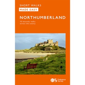
Wandelgids Northumberland | Ordnance Survey (9780319092309)
10 Leisurely Walks
- ISBN / CODE: 9780319092309
- Editie: 04-04-2022
- Aantal blz.: 80
- Uitgever: Ordnance Survey
- Soort: Wandelgids
- Serie: Short Walks Made Easy
- Taal: Engels
- Hoogte: 23.0 cm
- Breedte: 13.0 cm
- Dikte: 1.1 cm
- Gewicht: 164.0 g
- Bindwijze: Paperback
- Uitvoering: -
- Schrijf als eerste een review
-
€ 10,95
Dit artikel is (tijdelijk) niet leverbaar Dit artikel is (tijdelijk) niet leverbaar
- Afbeeldingen
- Inkijkexemplaar
Beschrijving
Explore the castles and coast of Northumberland from Dunstanburgh to Hadrian’s Wall with ten walks suitable for all ages and abilities. Discover England’s most northerly county from the North Sea coast to the North Pennines on hand-picked, leisurely rambles for the whole family.
Northumberland Short Walks Made Easy include:
- Circle dramatic Bamburgh Castle, looking out to the Farne Islands from wildlife-rich dunes, and see the grave of lifeboat heroine Grace Darling
- Enjoy the tranquility of secluded Wooler Common with its wealth of wildlife and ancient remains on the edge of the Cheviots
- Start at picturesque Craster and follow the coast path to Dunstanburgh Castle, a rugged ruin perched on a rocky, wave-battered headland
- Ramble the shores of Kielder Water, spot nesting ospreys and stumble upon the fascinating artworks in the forest
- Follow Hadrian’s Wall from Cawfields near Haltwhistle to see the iconic Roman structure close up, with stunning views in both directions
- Stroll along the banks of the River Tyne and see Hexham’s medieval abbey
- Climb Shaftoe Crags for far-reaching views of central Northumberland
OS Pathfinder Guides: Short Walks Made Easy:
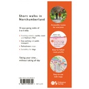
- 10 accessible walks suitable for the whole family
- All routes are between 2 to 5 miles and can be completed all year round
- Know what to expect before you go: Information on locations of cafes/pubs and toilets, terrain, hilliness and accessibility for pushchairs and wheelchairs
- Large-scale Ordnance Survey maps for ultra-easy navigation and route-finding, featuring intuitive pictorial symbols
- Numbered points which tie maps to route descriptions and walk profiles
- Route photographs for each numbered point so you know exactly where you’re going
- Discover GPS waypoints, parking information and detailed route descriptions for foolproof navigation
- Enhance your adventure with stories behind each walk and nature notes
- Get active outside and enjoy the physical and mental health benefits
Reviews
Geen reviews gevonden voor dit product.
Schrijf een review
Graag horen wij wat u van dit artikel vindt. Vindt u het goed, leuk, mooi, slecht, lelijk, onbruikbaar of erg handig: schrijf gerust alles op! Het is niet alleen leuk om te doen maar u informeert andere klanten er ook nog mee!
Alle gerelateerde rubrieken >
Ook interessant voor europa/engeland/northumberland-national-park
-

Wandelkaart - Topografische kaart 08
€ 19,50Topografische kaarten North East England -

Fietskaart Cycle Touring Map of Nort
€ 14,95Fietskaarten North East England -

Wandelgids St Cuthbert's Way | Cicer
€ 22,95Wandelgidsen North East England -

Reisverhaal Dwars door Engeland | Ma
€ 18,96Reisverhalen ♦ Northumberland National Park -

Fietsgids Cycling the Reivers Route
€ 16,50Fietsgidsen North East England


