Mandje Tel: +31503126950 Menu
Winkelwagen
Geen items in winkelwagen
Ga naar winkelwagen

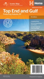
Wegenkaart - landkaart Iconic Map Top End and Gulf | Hema Maps (9321438001614)

Featuring Kakadu National Park

  • ISBN / CODE: 9321438001614
  • Editie: 01-07-2019
  • Druk: 7
  • Aantal blz.: 1
  • Schaal: 1:1650000
  • Uitgever: Hema Maps
  • Soort: Wegenkaart
  • Serie: Iconic Map
  • Taal: Engels
  • Hoogte: 25.0 cm
  • Breedte: 14.0 cm
  • Gewicht: 60.0 g
  • Bindwijze: -
  • Uitvoering: Scheur- en watervast
  • Schrijf als eerste een review
  • 15,95

    Dit artikel is (tijdelijk) niet leverbaar Dit artikel is (tijdelijk) niet leverbaar

Beschrijving

This regional waterproof map of the Top End and Gulf is ideal for discovering the northern parts of Australia's NT by 4WD. It includes a main map of the Darwin region, Judbarra / Gregory National Park, Nhulunbuy, Keep River National Park and Boodjamulla (Lawn Hill) National Park.
 
There is additional tourist information for Arnhem Land, the Roper River trek, Darwin region, Douglas-Daly district, Nature’s Way, Victoria Highway, Katherine Region and the Stuart Highway Region.
 
PRODUCT FEATURES
 
GPS surveyed roads and tracks
Fuel stops
Self-drive 4WD tracks
Camping areas
Historic sites
Detailed National Park inset maps
WHAT'S NEW IN THIS EDITION:
 
New edition, new layout
New cartographic map specifications
All inset maps are now provided in a better scale

Reviews

Geen reviews gevonden voor dit product.

Schrijf een review

Graag horen wij wat u van dit artikel vindt. Vindt u het goed, leuk, mooi, slecht, lelijk, onbruikbaar of erg handig: schrijf gerust alles op! Het is niet alleen leuk om te doen maar u informeert andere klanten er ook nog mee!