Categorieën
- Boeken
-
Kaarten
- Camperkaarten
- Educatieve kaarten
- Fietskaarten
- Fietsknooppuntenkaarten
- Historische Kaarten
- Pelgrimsroutes (kaarten)
- Spoorwegenkaarten
- Stadsplattegronden
- Toerskikaarten
- Topografische kaarten
- Wandelatlassen
-
Wandelkaarten
- Afrika
- Azië
-
Europa
- Albanië
- Andorra
- Armenië
- België
- Bulgarije
- Cyprus
- Denemarken
- Duitsland
- Engeland
- Faroer
- Finland
- Frankrijk
- Georgië
- Griekenland
- IJsland
- Ierland
- Italië
- Kosovo
- Kroatië
- Letland
- Liechtenstein
- Luxemburg
- Malta
- Montenegro
- Nederland
- Noord-Ierland
- Noord-Macedonië
- Noorwegen
- Oekraïne
- Oostenrijk
- Polen
- Portugal
- Roemenië
- Rusland
-
Schotland
- Schotse Hooglanden & Speyside
- ♦ Cairngorms National Park
- ♦ Loch Lomond & Trossach National Park
- Orkney Eilanden
- Shetlands | Shetlandeilanden
- Hebriden
- Ben Nevis - Glen Coe - Fort William
- Isle of Skye
- Arran
- Loch Ness en de Great Glen
- Centraal Schotland
- Lowlands | Schotse Laaglanden en grenzen
- ♦ Galloway Forest Park
- Edinburgh
- Glasgow
- 🥾 West Highland Way
- Servië
- Slovenië
- Slowakije
- Spanje
- Tsjechië
- Turkije
- Vaticaanstad
- Zweden
- Zwitserland
- Midden-Amerika
- Midden-Oosten
- Noord-Amerika
- Oceanië
- Zuid-Amerika
- Wandelknooppuntenkaarten
- Waterkaarten
- Wegenatlassen
- Wegenkaarten
- Wintersportkaarten
- Opruiming
- Puzzels
- Travel Gadgets
- Wandkaarten
- Wereldbollen
Veilig online betalen
Betaal veilig via uw eigen bankomgeving
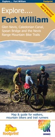
Wandelkaart Fort William | Footprint maps (9781916002920)
Glen Nevis, Caledonian Canal, Spean Bridge and the Nevis Range Mountain Bike Trails
- ISBN / CODE: 9781916002920
- Schaal: 1:35000
- Uitgever: Footprint maps
- Soort: Wandelkaart
- Taal: Engels
- Uitvoering: scheur- en watervast
- Schrijf als eerste een review
-
€ 14,95
Dit artikel is (tijdelijk) niet leverbaar Dit artikel is (tijdelijk) niet leverbaar
- Afbeeldingen
- Inkijkexemplaar
Beschrijving
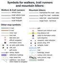
Gedetailleerde wandelkaart van dit gedeelte van Schotland. Ook zeer geschikt voor de mountainbike. Op de achterzijde detailkaartjes met wandel- en mountainbikeroutes. Inclusief veel praktische informatie.
Reviews
Geen reviews gevonden voor dit product.
Schrijf een review
Graag horen wij wat u van dit artikel vindt. Vindt u het goed, leuk, mooi, slecht, lelijk, onbruikbaar of erg handig: schrijf gerust alles op! Het is niet alleen leuk om te doen maar u informeert andere klanten er ook nog mee!
Ook interessant voor europa/schotland/ben-nevis-eo
-

Klimgids - Klettersteiggids Winter C
€ 34,95Klimgids - Klettersteiggidsen Ben Nevis - Glen Coe - Fort William -

Wandelkaart - Topografische kaart 39
€ 19,50Topografische kaarten Ben Nevis - Glen Coe - Fort William -

Wandelgids Fort William, Glen Coe an
€ 12,95Wandelgidsen Ben Nevis - Glen Coe - Fort William -

Wandelgids 007 Pathfinder Guides For
€ 18,50Wandelgidsen Schotse Hooglanden & Speyside -

Wandelkaart - Topografische kaart 37
€ 25,95Topografische kaarten Ben Nevis - Glen Coe - Fort William


