Categorieën
-
Boeken
- Aanwijswoordenboeken
- Accommodatiegidsen
- Atlassen
- Bed and Breakfast Gidsen
- Bergsporthandboeken
- Campergidsen
- Camperhandboeken
- Campinggidsen
- Duikgidsen
- Fietsatlassen
- Fietsgidsen
- Fotoboeken
- Historische Atlassen
- Kanogidsen
- Kinderatlassen
- Kinderreisgidsen
- Kleurboeken
- Klimgids - Klettersteiggidsen
- Klimgids - Klimtopo
- Kookboeken
- Mountainbikegidsen
- Natuurgidsen
- Pelgrimsroutes
- Reisboeken
- Reisdagboeken
- Reisfotografiegidsen
- Reisgidsen
- Reishandboeken
- Reisinspiratieboeken
- Reisverhalen
- Sneeuwschoenwandelgidsen
- Survivalgidsen
- Tourskigidsen
- Treinreisgidsen
- Vaargidsen
- Vogelgidsen
-
Wandelgidsen
- Afrika
- Azië
-
Europa
- Albanië
- Andorra
- Armenië
- België
- Bosnië - Hercegovina
- Bulgarije
- Cyprus
- Denemarken
- Duitsland
-
Engeland
- Noord Engeland
- North East England
- ♦ Northumberland National Park
- Yorkshire and the Humber
- ♦ Yorkshire Dales Nationaal Park
- ♦ North York Moors Nationaal Park
- ■ York
- North West England
- ♦ Cumbria
- ♦ Isle of Man
- ♦ Lake District Nationaal Park
- ♦ North Pennines AONB
- ■ Liverpool
- ■ Manchester
- 🥾 Hadrian's Wall Path
- East Midlands
- West Midlands
- ♦ Peak District Nationaal Park
- ■ Birmingham
- Wales
- Swansea and the Gower
- ♦ Pembrokeshire Coast National Park
- ♦ Snowdonia Nationaal Park
- ♦ Brecon Beacons Nationaal Park
- East of England - East Anglia
- ♦ The Broads National Park
- South West England
- Cornwall
- Devon
- Dorset
- ■ Bath
- ♦ Cotswolds AONB
- ♦ Devon - Cornwall
- 🥾 South West Coast Path
- ♦ New Forrest National Park
- ♦ Exmoor National Park
- ♦ Dartmoor National Park
- ■ Bristol
- South East England
- ♦ Kent
- ♦ South Downs Nationaal Park
- ♦ Isle of Wight
- ■ Londen
- ■ Oxford
- Kanaaleilanden
- ♦ Guernsey
- ♦ Jersey
- Meer steden
- Estland
- Faroer
- Finland
- Frankrijk
- Georgië
- Griekenland
- Groenland
- Hongarije
- IJsland
- Ierland
- Italië
- Kosovo
- Kroatië
- Letland
- Liechtenstein
- Litouwen
- Luxemburg
- Malta
- Montenegro
- Nederland
- Noord-Ierland
- Noord-Macedonië
- Noorwegen
- Oostenrijk
- Polen
- Portugal
- Roemenië
- Scandinavië
- Schotland
- Servië
- Slovenië
- Slowakije
- Spanje
- Tsjechië
- Turkije
- Zweden
- Zwitserland
- Midden-Amerika
- Midden-Oosten
- Noord-Amerika
- Oceanië
- Wereld
- Zuid-Amerika
- Watersport handboeken
- Werken en wonen in buitenland
- Woordenboeken & Taalgidsen
- Kaarten
- Opruiming
- Puzzels
- Travel Gadgets
- Wandkaarten
- Wereldbollen
Veilig online betalen
Betaal veilig via uw eigen bankomgeving
- U bent hier:
- Home
- Europa
- Engeland
- Yorkshire and the Humber
- Boeken
- Wandelgidsen
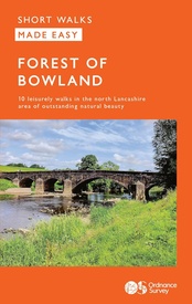
Wandelgids Forest of Bowland | Ordnance Survey (9780319092606)
- ISBN / CODE: 9780319092606
- Editie: 01-04-2023
- Aantal blz.: 80
- Uitgever: Ordnance Survey
- Soort: Wandelgids
- Serie: Short Walks Made Easy
- Taal: Engels
- Hoogte: 23.0 cm
- Breedte: 13.0 cm
- Gewicht: 124.0 g
- Bindwijze: Paperback
- Uitvoering: -
- Schrijf als eerste een review
-
€ 10,95
Leverbaar in 3 - 5 werkdagen in huis in Belgie Levertijd Nederland Leverbaar in 3 - 5 werkdagen in huis in Nederland Levertijd Belgie
Gratis verzending in Nederland vanaf €35,-
- Afbeeldingen
- Inkijkexemplaar
Beschrijving
Van de uitgever
This guide contains ten family-friendly and easy-paced short, circular walks covering the Bowland AONB. The turn-by-turn route directions with waypoint photos guide you safely to pretty villages, historic towns and along accessible waterside trails, across fells and through forest. You can read about the ghosts of Lancaster Castle, identify moorland wildlife, and find scenic picnic sites or cafés to complete your day.
Around the Forest of Bowland fringes at Caton, Lancaster, Scorton, Garstang and Clitheroe, you can enjoy riparian rambles along the Lune and Ribble, and strolls beside the Lancaster and Leeds & Liverpool canals. At Gisburn, Dunsop Bridge and Beacon Fell easy-going trails lead to the heart of Bowland’s moorlands and forests.
Ten easy-to-follow leisurely walks
Distance: 2 to 5 miles
Stunning scenery: moors, forests, rivers and canals
Navigate your way: simplified mapping, route profiles, turn-by-turn instructions, or walk photography
Packed with essential information for easy planning:
Public transport links and parking spots
Terrain and footwear information
Refreshment stops including pubs and cafes
Public toilet markers
Nature notes for the area
Stories behind each walk
Highlighted accessibility sections for wheelchair and pushchair users
Dog friendly information
Reviews
Geen reviews gevonden voor dit product.
Schrijf een review
Graag horen wij wat u van dit artikel vindt. Vindt u het goed, leuk, mooi, slecht, lelijk, onbruikbaar of erg handig: schrijf gerust alles op! Het is niet alleen leuk om te doen maar u informeert andere klanten er ook nog mee!
Ook interessant voor europa/engeland/yorkshire-and-the-humber
-

Wegenkaart - landkaart Visitors map
€ 11,50Wegenkaarten Yorkshire and the Humber -

Stadsplattegrond Pocket Street Map S
€ 7,95Stadsplattegronden Yorkshire and the Humber -

Reisverhaal Walking the Wharfe | Joh
€ 14,95Reisverhalen Yorkshire and the Humber -

Wandelkaart - Topografische kaart 29
€ 19,50Topografische kaarten Yorkshire and the Humber -

Reisgids 111 places in Places in Yor
€ 19,95Reisgidsen Yorkshire and the Humber


