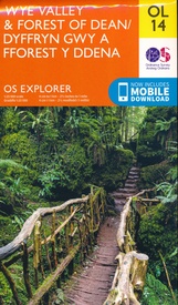
Wandelkaart - Topografische kaart OL14 OS Explorer Map Wye Valley - Forest of Dean - Dyfryn Gwy | Ordnance Survey (9780319263839)
- ISBN / CODE: 9780319263839
- Editie: meest recente versie
- Schaal: 1:25000
- Uitgever: Ordnance Survey
- Soort: Topografische kaart, Wandelkaart
- Serie: OS Explorer Map
- Taal: Engels
- Uitvoering: -
- Bindwijze: -
- Beoordeling: 5,0 ★★★★★ (1 review) Schrijf een review
-
€ 19,50
Leverbaar in 3 - 5 werkdagen in huis in Nederland Levertijd Belgie
Gratis verzending in Nederland vanaf €35,-
-
Overzichtskaart Explorer 25.000 topografische kaarten Midden Engeland - Midlands

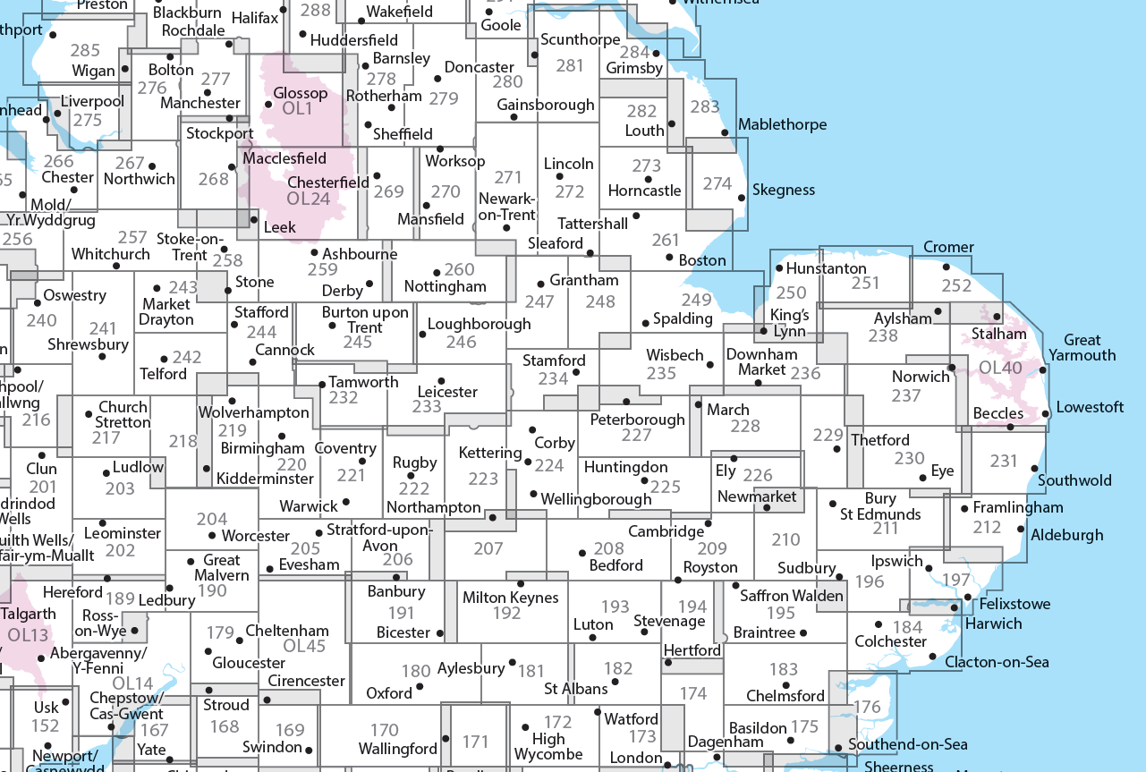
Producten op deze overzichtskaart:
Klik op een product om naar de pagina van dat product te gaan.
- Wandelkaart - Topografische kaart 179 OS Explorer Map Gloucester, Cheltenham, Stroud | Ordnance Survey
- Wandelkaart - Topografische kaart 180 OS Explorer Map Oxford | Ordnance Survey
- Wandelkaart - Topografische kaart 182 OS Explorer Map St-Albans, Hatfield | Ordnance Survey
- Wandelkaart - Topografische kaart 189 OS Explorer Map Hereford & Ross-on-Wye | Ordnance Survey
- Wandelkaart - Topografische kaart 190 OS Explorer Map Malvern Hills, Bredon Hill | Ordnance Survey
- Wandelkaart - Topografische kaart 191 OS Explorer Map Banbury, Bicester, Chipping Norton | Ordnance Survey
- Wandelkaart - Topografische kaart 192 OS Explorer Map Buckingham, Milton Keynes | Ordnance Survey
- Wandelkaart - Topografische kaart 193 OS Explorer Map Luton, Stevenage | Ordnance Survey
- Wandelkaart - Topografische kaart 194 OS Explorer Map Hertford, Bishop's Stortford | Ordnance Survey
- Wandelkaart - Topografische kaart 202 OS Explorer Map Leominster, Bromyard | Ordnance Survey
- Wandelkaart - Topografische kaart 203 OS Explorer Map Ludlow | Ordnance Survey
- Wandelkaart - Topografische kaart 204 OS Explorer Map Worcester, Droitwich Spa | Ordnance Survey
- Wandelkaart - Topografische kaart 205 OS Explorer Map Stratford-upon-Avon, Evesham | Ordnance Survey
- Wandelkaart - Topografische kaart 206 OS Explorer Map Edge Hill, Fenny Compton | Ordnance Survey
- Wandelkaart - Topografische kaart 207 OS Explorer Map Newport Pagnell, Northampton South | Ordnance Survey
- Wandelkaart - Topografische kaart 208 OS Explorer Map Bedford, St Neots | Ordnance Survey
- Wandelkaart - Topografische kaart 209 OS Explorer Map Cambridge (greenw.m) | Ordnance Survey
- Wandelkaart - Topografische kaart 217 OS Explorer Map Long Mynd, Wenlock Edge | Ordnance Survey
- Wandelkaart - Topografische kaart 218 OS Explorer Map Kidderminster, Wyre Forest | Ordnance Survey
- Wandelkaart - Topografische kaart 219 OS Explorer Map Wolverhampton, Dudley | Ordnance Survey
- Wandelkaart - Topografische kaart 220 OS Explorer Map Birmingham | Ordnance Survey
- Wandelkaart - Topografische kaart 221 OS Explorer Map Coventry, Warwick | Ordnance Survey
- Wandelkaart - Topografische kaart 222 OS Explorer Map Rugby, Daventry | Ordnance Survey
- Wandelkaart - Topografische kaart 223 OS Explorer Map Northampton, Market Harborough | Ordnance Survey
- Wandelkaart - Topografische kaart 224 OS Explorer Map Corby, Kettering, Wellingborough | Ordnance Survey
- Wandelkaart - Topografische kaart 225 OS Explorer Map Huntingdon, St Ives | Ordnance Survey
- Wandelkaart - Topografische kaart 227 OS Explorer Map Peterborough, March, Whittlesey, Chatteris, Oundle | Ordnance Survey
- Wandelkaart - Topografische kaart 228 OS Explorer Map March, Ely, Chatteris, Littleport | Ordnance Survey
- Wandelkaart - Topografische kaart 232 OS Explorer Map Nuneaton, Tamworth | Ordnance Survey
- Wandelkaart - Topografische kaart 233 OS Explorer Map Leicester, Hinckley | Ordnance Survey
- Wandelkaart - Topografische kaart 234 OS Explorer Map Rutland Water, Stamford, Oakham | Ordnance Survey
- Wandelkaart - Topografische kaart 235 OS Explorer Map Wisbech, Peterborough North, Market Deeping | Ordnance Survey
- Wandelkaart - Topografische kaart 241 OS Explorer Map Shrewsbury | Ordnance Survey
- Wandelkaart - Topografische kaart 242 OS Explorer Map Telford, Ironbridge, the Wrekin | Ordnance Survey
- Wandelkaart - Topografische kaart 243 OS Explorer Map Market Drayton | Ordnance Survey
- Wandelkaart - Topografische kaart 244 OS Explorer Map Cannock Chase, Chasewater | Ordnance Survey
- Wandelkaart - Topografische kaart 245 OS Explorer Map National Forest | Ordnance Survey
- Wandelkaart - Topografische kaart 246 OS Explorer Map Loughborough | Ordnance Survey
- Wandelkaart - Topografische kaart 247 OS Explorer Map Grantham | Ordnance Survey
- Wandelkaart - Topografische kaart 248 OS Explorer Map Bourne, Heckington | Ordnance Survey
- Wandelkaart - Topografische kaart 249 OS Explorer Map Spalding, Holbeach | Ordnance Survey
- Wandelkaart - Topografische kaart 257 OS Explorer Map Crewe, Nantwich | Ordnance Survey
- Wandelkaart - Topografische kaart 258 OS Explorer Map Stoke-on-Trent, Newcastle-under-Lyme | Ordnance Survey
- Wandelkaart - Topografische kaart 259 OS Explorer Map Derby, Utoxeter | Ordnance Survey
- Wandelkaart - Topografische kaart 260 OS Explorer Map Nottingham | Ordnance Survey
- Wandelkaart - Topografische kaart 261 OS Explorer Map Boston | Ordnance Survey
- Wandelkaart - Topografische kaart 267 OS Explorer Map Northwich & Delamere Forest | Ordnance Survey
- Wandelkaart - Topografische kaart 268 OS Explorer Map Wilmslow, Macclesfield & Congleton | Ordnance Survey
- Wandelkaart - Topografische kaart 269 OS Explorer Map Chesterfield & Alfreton | Ordnance Survey
- Wandelkaart - Topografische kaart 270 OS Explorer Map Sherwood Forest | Ordnance Survey
- Wandelkaart - Topografische kaart 271 OS Explorer Map Newark-on-Trent | Ordnance Survey
- Wandelkaart - Topografische kaart 272 OS Explorer Map Lincoln | Ordnance Survey
- Wandelkaart - Topografische kaart 273 OS Explorer Map Lincolnshire Wolds South | Ordnance Survey
- Wandelkaart - Topografische kaart 274 OS Explorer Map Skegness, Alford & Spilsby | Ordnance Survey
- Wandelkaart - Topografische kaart 275 OS Explorer Map Liverpool St Helens, Widnes & Runcorn | Ordnance Survey
- Wandelkaart - Topografische kaart 276 OS Explorer Map Bolton Central, Wigan & Warrington | Ordnance Survey
- Wandelkaart - Topografische kaart 277 OS Explorer Map Manchester & Salford | Ordnance Survey
- Wandelkaart - Topografische kaart 278 OS Explorer Map Sheffield & Barnsley | Ordnance Survey
- Wandelkaart - Topografische kaart 279 OS Explorer Map Doncaster | Ordnance Survey
- Wandelkaart - Topografische kaart 280 OS Explorer Map Isle of Axholme | Ordnance Survey
- Wandelkaart - Topografische kaart 281 OS Explorer Map Ancholme Valley | Ordnance Survey
- Wandelkaart - Topografische kaart 282 OS Explorer Map Lincolnshire Wolds North | Ordnance Survey
- Wandelkaart - Topografische kaart 283 OS Explorer Map Louth, Mablethorpe | Ordnance Survey
- Wandelkaart - Topografische kaart 284 OS Explorer Map Grimsby, Cleethorpes, Immingham | Ordnance Survey
- Wandelkaart - Topografische kaart OL01 OS Explorer Map The Peak District - Dark Peak Area | Ordnance Survey
- Wandelkaart - Topografische kaart OL14 OS Explorer Map Wye Valley - Forest of Dean - Dyfryn Gwy | Ordnance Survey
- Wandelkaart - Topografische kaart OL24 OS Explorer Map The Peak District - White Peak Area | Ordnance Survey
- Wandelkaart - Topografische kaart OL45 OS Explorer Map The Cotswolds | Ordnance Survey
-
Overzichtskaart Explorer 25.000 topografische kaarten Wales
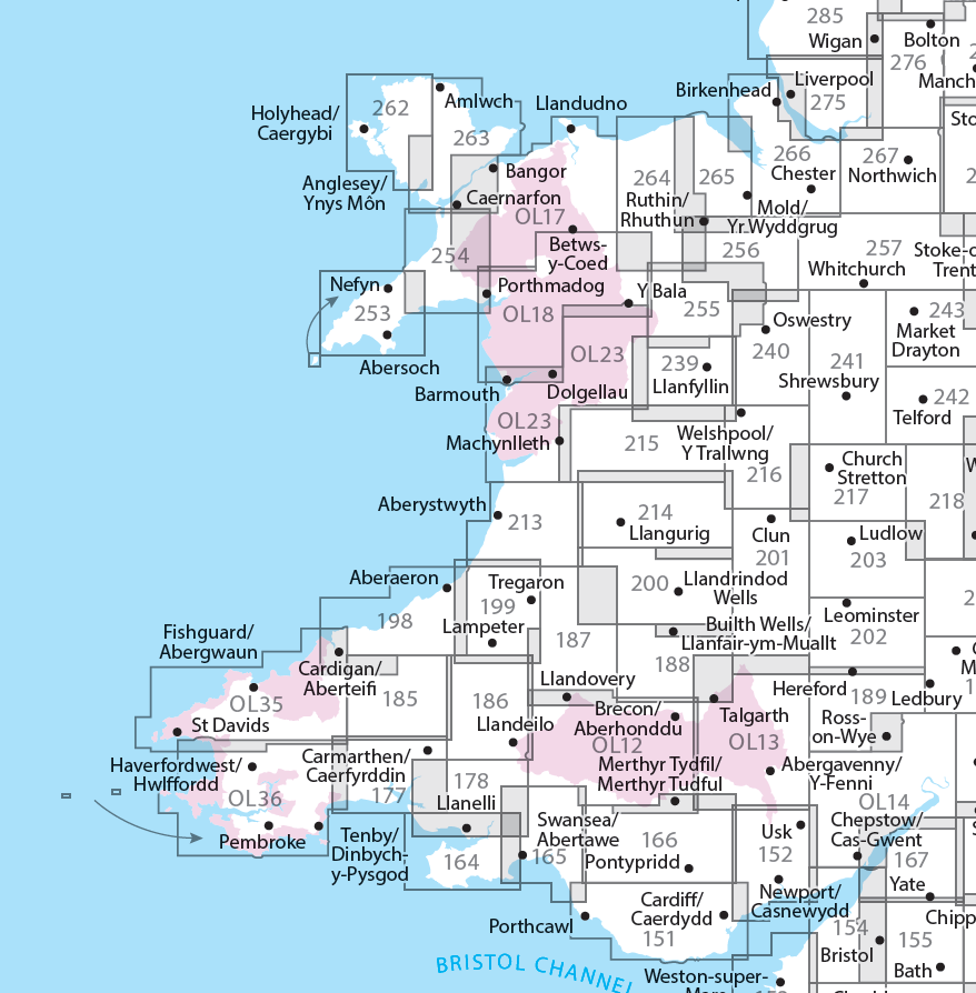
Producten op deze overzichtskaart:
Klik op een product om naar de pagina van dat product te gaan.
- Wandelkaart - Topografische kaart 151 OS Explorer Map Cardiff & Bridgend | Ordnance Survey
- Wandelkaart - Topografische kaart 152 OS Explorer Map Newport, Pontypool | Ordnance Survey
- Wandelkaart - Topografische kaart 164 OS Explorer Map Gower, Gwyr | Ordnance Survey
- Wandelkaart - Topografische kaart 165 OS Explorer Map Swansea, Abertawe | Ordnance Survey
- Wandelkaart - Topografische kaart 166 OS Explorer Map Rhondda, Merthyr Tydfil | Ordnance Survey
- Wandelkaart - Topografische kaart 177 OS Explorer Map Carmarthen, Kidwelly | Ordnance Survey
- Wandelkaart - Topografische kaart 178 OS Explorer Map Llanelli, Ammanford, Rhydaman | Ordnance Survey
- Wandelkaart - Topografische kaart 185 OS Explorer Map Newcastle Emlyn | Ordnance Survey
- Wandelkaart - Topografische kaart 186 OS Explorer Map Llandeilo, Brechfa Forest | Ordnance Survey
- Wandelkaart - Topografische kaart 187 OS Explorer Map Llandovery | Ordnance Survey
- Wandelkaart - Topografische kaart 188 OS Explorer Map Builth Wells, Llanfair-ym-Muallt | Ordnance Survey
- Wandelkaart - Topografische kaart 189 OS Explorer Map Hereford & Ross-on-Wye | Ordnance Survey
- Wandelkaart - Topografische kaart 198 OS Explorer Map Cardigan, New Quay | Ordnance Survey
- Wandelkaart - Topografische kaart 199 OS Explorer Map Lampeter | Ordnance Survey
- Wandelkaart - Topografische kaart 200 OS Explorer Map Llandrindod Wells, Elan Valley | Ordnance Survey
- Wandelkaart - Topografische kaart 201 OS Explorer Map Knighton, Presteigne | Ordnance Survey
- Wandelkaart - Topografische kaart 202 OS Explorer Map Leominster, Bromyard | Ordnance Survey
- Wandelkaart - Topografische kaart 203 OS Explorer Map Ludlow | Ordnance Survey
- Wandelkaart - Topografische kaart 213 OS Explorer Map Aberystwyth, Cwm Rheidol | Ordnance Survey
- Wandelkaart - Topografische kaart 214 OS Explorer Map Llanidloes, Newtown, Y Drenewydd | Ordnance Survey
- Wandelkaart - Topografische kaart 215 OS Explorer Map Newtown, Machynlleth | Ordnance Survey
- Wandelkaart - Topografische kaart 216 OS Explorer Map Welshpool, Montgomery | Ordnance Survey
- Wandelkaart - Topografische kaart 217 OS Explorer Map Long Mynd, Wenlock Edge | Ordnance Survey
- Wandelkaart - Topografische kaart 239 OS Explorer Map Lake Vyrnwy, Efyrnwy | Ordnance Survey
- Wandelkaart - Topografische kaart 240 OS Explorer Map Oswestry | Ordnance Survey
- Wandelkaart - Topografische kaart 241 OS Explorer Map Shrewsbury | Ordnance Survey
- Wandelkaart - Topografische kaart 253 OS Explorer Map Lleyn Peninsula West | Ordnance Survey
- Wandelkaart - Topografische kaart 254 OS Explorer Map Lleyn Peninsula East | Ordnance Survey
- Wandelkaart - Topografische kaart 255 OS Explorer Map Llangollen, Berwyn | Ordnance Survey
- Wandelkaart - Topografische kaart 256 OS Explorer Map Wrexham, Wrecsam, Llangollen | Ordnance Survey
- Wandelkaart - Topografische kaart 257 OS Explorer Map Crewe, Nantwich | Ordnance Survey
- Wandelkaart - Topografische kaart 262 OS Explorer Map Anglesey West | Ordnance Survey
- Wandelkaart - Topografische kaart 263 OS Explorer Map Anglesey East | Ordnance Survey
- Wandelkaart - Topografische kaart 264 OS Explorer Map Vale of Clwyd, Dyffryn Clwyd | Ordnance Survey
- Wandelkaart - Topografische kaart 265 OS Explorer Map Clwydian Range | Ordnance Survey
- Wandelkaart - Topografische kaart 266 OS Explorer Map Wirral & Chester | Ordnance Survey
- Wandelkaart - Topografische kaart 267 OS Explorer Map Northwich & Delamere Forest | Ordnance Survey
- Wandelkaart - Topografische kaart 275 OS Explorer Map Liverpool St Helens, Widnes & Runcorn | Ordnance Survey
- Wandelkaart - Topografische kaart OL12 OS Explorer Map Brecon Beacons NP West | Ordnance Survey
- Wandelkaart - Topografische kaart OL13 OS Explorer Map Brecon Beacons NP East | Ordnance Survey
- Wandelkaart - Topografische kaart OL14 OS Explorer Map Wye Valley - Forest of Dean - Dyfryn Gwy | Ordnance Survey
- Wandelkaart - Topografische kaart OL17 OS Explorer Map Snowdon - Conwy Valley - Dyffryn Conwy | Ordnance Survey
- Wandelkaart - Topografische kaart OL18 OS Explorer Map Harlech - Porthmadog - Y Bala | Ordnance Survey
- Wandelkaart - Topografische kaart OL23 OS Explorer Map Cadair Idris & Bala Lake | Ordnance Survey
- Wandelkaart - Topografische kaart OL35 OS Explorer Map North Pembrokeshire | Ordnance Survey
- Wandelkaart - Topografische kaart OL36 OS Explorer Map South Pembrokeshire | Ordnance Survey
-
Overzichtskaart Explorer 25.000 topografische kaarten zuid Engeland

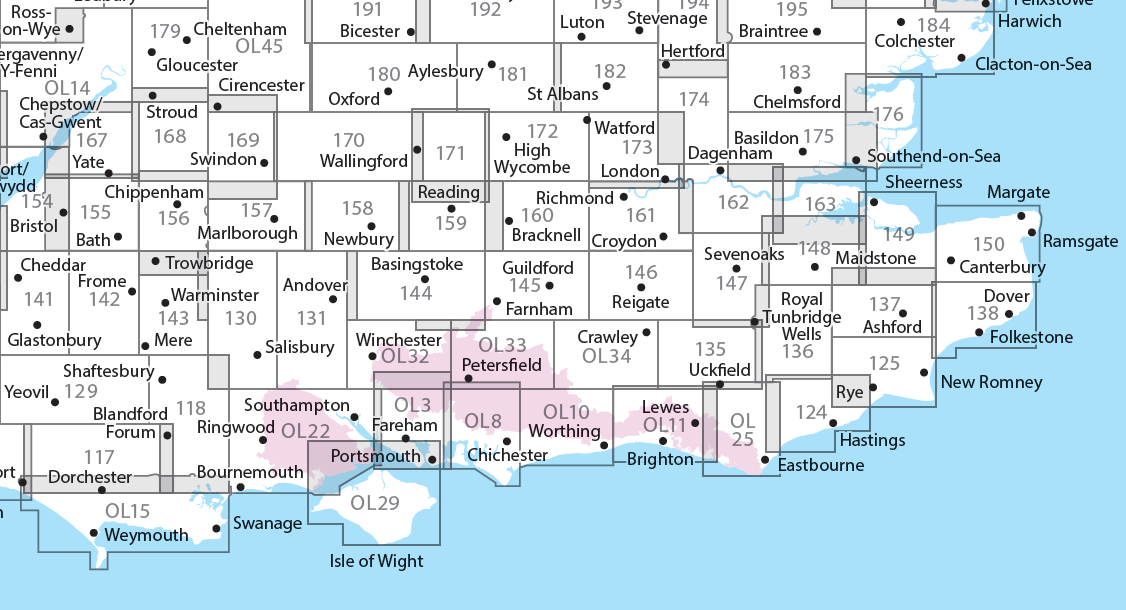
Producten op deze overzichtskaart:
Klik op een product om naar de pagina van dat product te gaan.
- Wandelkaart - Topografische kaart 117 OS Explorer Map Cerne Abbas & Bere Regis | Ordnance Survey
- Wandelkaart - Topografische kaart 118 OS Explorer Map Shaftesbury & Cranborne Chase | Ordnance Survey
- Wandelkaart - Topografische kaart 129 OS Explorer Map Yeovil & Sherborne | Ordnance Survey
- Wandelkaart - Topografische kaart 130 OS Explorer Map Salisbury & Stonehenge | Ordnance Survey
- Wandelkaart - Topografische kaart 131 OS Explorer Map Romsey, Andover & Test Valley | Ordnance Survey
- Wandelkaart - Topografische kaart 135 OS Explorer Map Ashdown Forest (greenw) | Ordnance Survey
- Wandelkaart - Topografische kaart 141 OS Explorer Map Cheddar Gorge, Mendip Hills West | Ordnance Survey
- Wandelkaart - Topografische kaart 142 OS Explorer Map Shepton Mallet , Mendip Hills East | Ordnance Survey
- Wandelkaart - Topografische kaart 143 OS Explorer Map Warminster, Trowbridge | Ordnance Survey
- Wandelkaart - Topografische kaart 144 OS Explorer Map Basingstoke, Alto, Whitchurch | Ordnance Survey
- Wandelkaart - Topografische kaart 145 OS Explorer Map Guildford, Farnham | Ordnance Survey
- Wandelkaart - Topografische kaart 146 OS Explorer Map Dorking, Box Hill, Reigate | Ordnance Survey
- Wandelkaart - Topografische kaart 147 OS Explorer Map Sevenoaks and Tonbridge | Ordnance Survey
- Wandelkaart - Topografische kaart 154 OS Explorer Map Bristol West, Portishead | Ordnance Survey
- Wandelkaart - Topografische kaart 155 OS Explorer Map Bristol, Bath | Ordnance Survey
- Wandelkaart - Topografische kaart 156 OS Explorer Map Chippenham, Bradford-on-Avon | Ordnance Survey
- Wandelkaart - Topografische kaart 157 OS Explorer Map Marlborough, Savernake Forest | Ordnance Survey
- Wandelkaart - Topografische kaart 158 OS Explorer Map Newbury, Hungerford | Ordnance Survey
- Wandelkaart - Topografische kaart 159 OS Explorer Map Reading, Wokingham & Pangbourne Map | Thames Path | Ordnance Survey
- Wandelkaart - Topografische kaart 160 OS Explorer Map Windsor, Weybridge, Bracknell | Thames Path | Ordnance Survey
- Wandelkaart - Topografische kaart 161 OS Explorer Map London South (greenw.m) | Ordnance Survey
- Wandelkaart - Topografische kaart 162 OS Explorer Map Greenwich, Gravesend | Ordnance Survey
- Wandelkaart - Topografische kaart 167 OS Explorer Map Thornbury, Dursley, Yate | Ordnance Survey
- Wandelkaart - Topografische kaart 168 OS Explorer Map Stroud, Tetbury, Malmesbury | Ordnance Survey
- Wandelkaart - Topografische kaart 169 OS Explorer Map Cirencester, Swindon | Ordnance Survey
- Wandelkaart - Topografische kaart 170 OS Explorer Map Abingdon, Wantage & Vale of White Horse | Ordnance Survey
- Wandelkaart - Topografische kaart 171 OS Explorer Map Chiltern Hills West | Ordnance Survey
- Wandelkaart - Topografische kaart 172 OS Explorer Map Chiltern Hills East | Ordnance Survey
- Wandelkaart - Topografische kaart 173 OS Explorer Map London North | Ordnance Survey
- Wandelkaart - Topografische kaart 174 OS Explorer Map Epping Forest, Lee Valley | Ordnance Survey
- Wandelkaart - Topografische kaart 179 OS Explorer Map Gloucester, Cheltenham, Stroud | Ordnance Survey
- Wandelkaart - Topografische kaart 180 OS Explorer Map Oxford | Ordnance Survey
- Wandelkaart - Topografische kaart 182 OS Explorer Map St-Albans, Hatfield | Ordnance Survey
- Wandelkaart - Topografische kaart OL03 OS Explorer Map Meon Valley - Portsmouth, Gosport & Fareham | Ordnance Survey
- Wandelkaart - Topografische kaart OL08 OS Explorer Map Chichester, South Harting & Selsey | Ordnance Survey
- Wandelkaart - Topografische kaart OL10 OS Explorer Map Arundel - Pulborough - Worthing | Ordnance Survey
- Wandelkaart - Topografische kaart OL11 OS Explorer Map Brighton & Hove, Lewes & Burgess Hill | Ordnance Survey
- Wandelkaart - Topografische kaart OL14 OS Explorer Map Wye Valley - Forest of Dean - Dyfryn Gwy | Ordnance Survey
- Wandelkaart - Topografische kaart OL15 OS Explorer Map Purbeck and South Dorset | Ordnance Survey
- Wandelkaart - Topografische kaart OL25 OS Explorer Map Eastbourne & Beachy Head | Ordnance Survey
- Wandelkaart - Topografische kaart OL29 OS Explorer Map Isle of Wight | Ordnance Survey
- Wandelkaart - Topografische kaart OL32 OS Explorer Map Winchester | Ordnance Survey
- Wandelkaart - Topografische kaart OL33 OS Explorer Map Haslemere & Petersfield | Ordnance Survey
- Wandelkaart - Topografische kaart OL34 OS Explorer Map Crawley & Horsham | Ordnance Survey
-
Overzichtskaart Explorer 25.000 wandelkaarten Midden Engeland - Midlands

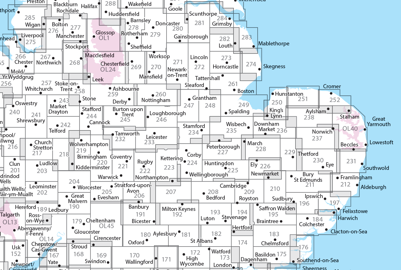
Producten op deze overzichtskaart:
Klik op een product om naar de pagina van dat product te gaan.
- Wandelkaart - Topografische kaart 179 OS Explorer Map Gloucester, Cheltenham, Stroud | Ordnance Survey
- Wandelkaart - Topografische kaart 180 OS Explorer Map Oxford | Ordnance Survey
- Wandelkaart - Topografische kaart 182 OS Explorer Map St-Albans, Hatfield | Ordnance Survey
- Wandelkaart - Topografische kaart 189 OS Explorer Map Hereford & Ross-on-Wye | Ordnance Survey
- Wandelkaart - Topografische kaart 190 OS Explorer Map Malvern Hills, Bredon Hill | Ordnance Survey
- Wandelkaart - Topografische kaart 191 OS Explorer Map Banbury, Bicester, Chipping Norton | Ordnance Survey
- Wandelkaart - Topografische kaart 192 OS Explorer Map Buckingham, Milton Keynes | Ordnance Survey
- Wandelkaart - Topografische kaart 193 OS Explorer Map Luton, Stevenage | Ordnance Survey
- Wandelkaart - Topografische kaart 194 OS Explorer Map Hertford, Bishop's Stortford | Ordnance Survey
- Wandelkaart - Topografische kaart 202 OS Explorer Map Leominster, Bromyard | Ordnance Survey
- Wandelkaart - Topografische kaart 203 OS Explorer Map Ludlow | Ordnance Survey
- Wandelkaart - Topografische kaart 204 OS Explorer Map Worcester, Droitwich Spa | Ordnance Survey
- Wandelkaart - Topografische kaart 205 OS Explorer Map Stratford-upon-Avon, Evesham | Ordnance Survey
- Wandelkaart - Topografische kaart 206 OS Explorer Map Edge Hill, Fenny Compton | Ordnance Survey
- Wandelkaart - Topografische kaart 207 OS Explorer Map Newport Pagnell, Northampton South | Ordnance Survey
- Wandelkaart - Topografische kaart 208 OS Explorer Map Bedford, St Neots | Ordnance Survey
- Wandelkaart - Topografische kaart 209 OS Explorer Map Cambridge (greenw.m) | Ordnance Survey
- Wandelkaart - Topografische kaart 217 OS Explorer Map Long Mynd, Wenlock Edge | Ordnance Survey
- Wandelkaart - Topografische kaart 218 OS Explorer Map Kidderminster, Wyre Forest | Ordnance Survey
- Wandelkaart - Topografische kaart 219 OS Explorer Map Wolverhampton, Dudley | Ordnance Survey
- Wandelkaart - Topografische kaart 220 OS Explorer Map Birmingham | Ordnance Survey
- Wandelkaart - Topografische kaart 221 OS Explorer Map Coventry, Warwick | Ordnance Survey
- Wandelkaart - Topografische kaart 222 OS Explorer Map Rugby, Daventry | Ordnance Survey
- Wandelkaart - Topografische kaart 223 OS Explorer Map Northampton, Market Harborough | Ordnance Survey
- Wandelkaart - Topografische kaart 224 OS Explorer Map Corby, Kettering, Wellingborough | Ordnance Survey
- Wandelkaart - Topografische kaart 225 OS Explorer Map Huntingdon, St Ives | Ordnance Survey
- Wandelkaart - Topografische kaart 227 OS Explorer Map Peterborough, March, Whittlesey, Chatteris, Oundle | Ordnance Survey
- Wandelkaart - Topografische kaart 228 OS Explorer Map March, Ely, Chatteris, Littleport | Ordnance Survey
- Wandelkaart - Topografische kaart 232 OS Explorer Map Nuneaton, Tamworth | Ordnance Survey
- Wandelkaart - Topografische kaart 233 OS Explorer Map Leicester, Hinckley | Ordnance Survey
- Wandelkaart - Topografische kaart 234 OS Explorer Map Rutland Water, Stamford, Oakham | Ordnance Survey
- Wandelkaart - Topografische kaart 235 OS Explorer Map Wisbech, Peterborough North, Market Deeping | Ordnance Survey
- Wandelkaart - Topografische kaart 241 OS Explorer Map Shrewsbury | Ordnance Survey
- Wandelkaart - Topografische kaart 242 OS Explorer Map Telford, Ironbridge, the Wrekin | Ordnance Survey
- Wandelkaart - Topografische kaart 243 OS Explorer Map Market Drayton | Ordnance Survey
- Wandelkaart - Topografische kaart 244 OS Explorer Map Cannock Chase, Chasewater | Ordnance Survey
- Wandelkaart - Topografische kaart 245 OS Explorer Map National Forest | Ordnance Survey
- Wandelkaart - Topografische kaart 246 OS Explorer Map Loughborough | Ordnance Survey
- Wandelkaart - Topografische kaart 247 OS Explorer Map Grantham | Ordnance Survey
- Wandelkaart - Topografische kaart 248 OS Explorer Map Bourne, Heckington | Ordnance Survey
- Wandelkaart - Topografische kaart 249 OS Explorer Map Spalding, Holbeach | Ordnance Survey
- Wandelkaart - Topografische kaart 257 OS Explorer Map Crewe, Nantwich | Ordnance Survey
- Wandelkaart - Topografische kaart 258 OS Explorer Map Stoke-on-Trent, Newcastle-under-Lyme | Ordnance Survey
- Wandelkaart - Topografische kaart 259 OS Explorer Map Derby, Utoxeter | Ordnance Survey
- Wandelkaart - Topografische kaart 260 OS Explorer Map Nottingham | Ordnance Survey
- Wandelkaart - Topografische kaart 261 OS Explorer Map Boston | Ordnance Survey
- Wandelkaart - Topografische kaart 267 OS Explorer Map Northwich & Delamere Forest | Ordnance Survey
- Wandelkaart - Topografische kaart 268 OS Explorer Map Wilmslow, Macclesfield & Congleton | Ordnance Survey
- Wandelkaart - Topografische kaart 269 OS Explorer Map Chesterfield & Alfreton | Ordnance Survey
- Wandelkaart - Topografische kaart 270 OS Explorer Map Sherwood Forest | Ordnance Survey
- Wandelkaart - Topografische kaart 271 OS Explorer Map Newark-on-Trent | Ordnance Survey
- Wandelkaart - Topografische kaart 272 OS Explorer Map Lincoln | Ordnance Survey
- Wandelkaart - Topografische kaart 273 OS Explorer Map Lincolnshire Wolds South | Ordnance Survey
- Wandelkaart - Topografische kaart 274 OS Explorer Map Skegness, Alford & Spilsby | Ordnance Survey
- Wandelkaart - Topografische kaart 275 OS Explorer Map Liverpool St Helens, Widnes & Runcorn | Ordnance Survey
- Wandelkaart - Topografische kaart 276 OS Explorer Map Bolton Central, Wigan & Warrington | Ordnance Survey
- Wandelkaart - Topografische kaart 277 OS Explorer Map Manchester & Salford | Ordnance Survey
- Wandelkaart - Topografische kaart 278 OS Explorer Map Sheffield & Barnsley | Ordnance Survey
- Wandelkaart - Topografische kaart 279 OS Explorer Map Doncaster | Ordnance Survey
- Wandelkaart - Topografische kaart 280 OS Explorer Map Isle of Axholme | Ordnance Survey
- Wandelkaart - Topografische kaart 281 OS Explorer Map Ancholme Valley | Ordnance Survey
- Wandelkaart - Topografische kaart 282 OS Explorer Map Lincolnshire Wolds North | Ordnance Survey
- Wandelkaart - Topografische kaart 283 OS Explorer Map Louth, Mablethorpe | Ordnance Survey
- Wandelkaart - Topografische kaart 284 OS Explorer Map Grimsby, Cleethorpes, Immingham | Ordnance Survey
- Wandelkaart - Topografische kaart OL01 OS Explorer Map The Peak District - Dark Peak Area | Ordnance Survey
- Wandelkaart - Topografische kaart OL14 OS Explorer Map Wye Valley - Forest of Dean - Dyfryn Gwy | Ordnance Survey
- Wandelkaart - Topografische kaart OL24 OS Explorer Map The Peak District - White Peak Area | Ordnance Survey
- Wandelkaart - Topografische kaart OL40 OS Explorer Map The Broads | Ordnance Survey
- Wandelkaart - Topografische kaart OL45 OS Explorer Map The Cotswolds | Ordnance Survey
-
Overzichtskaart Explorer 25.000 wandelkaarten Wales
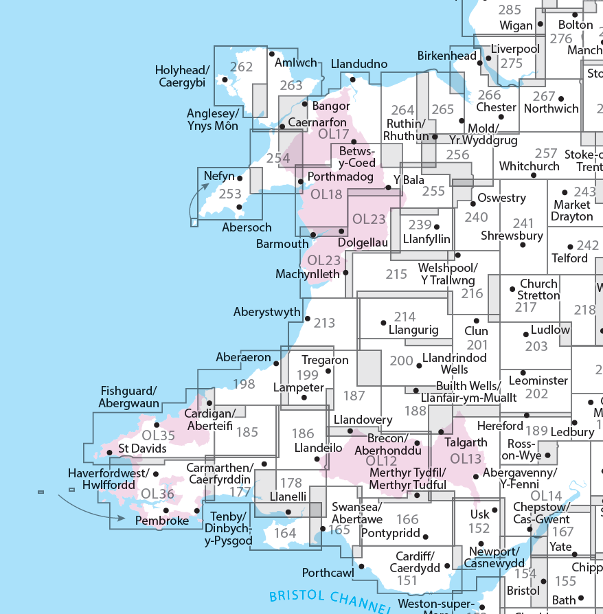
Producten op deze overzichtskaart:
Klik op een product om naar de pagina van dat product te gaan.
- Wandelkaart - Topografische kaart 151 OS Explorer Map Cardiff & Bridgend | Ordnance Survey
- Wandelkaart - Topografische kaart 152 OS Explorer Map Newport, Pontypool | Ordnance Survey
- Wandelkaart - Topografische kaart 164 OS Explorer Map Gower, Gwyr | Ordnance Survey
- Wandelkaart - Topografische kaart 165 OS Explorer Map Swansea, Abertawe | Ordnance Survey
- Wandelkaart - Topografische kaart 166 OS Explorer Map Rhondda, Merthyr Tydfil | Ordnance Survey
- Wandelkaart - Topografische kaart 177 OS Explorer Map Carmarthen, Kidwelly | Ordnance Survey
- Wandelkaart - Topografische kaart 178 OS Explorer Map Llanelli, Ammanford, Rhydaman | Ordnance Survey
- Wandelkaart - Topografische kaart 185 OS Explorer Map Newcastle Emlyn | Ordnance Survey
- Wandelkaart - Topografische kaart 186 OS Explorer Map Llandeilo, Brechfa Forest | Ordnance Survey
- Wandelkaart - Topografische kaart 187 OS Explorer Map Llandovery | Ordnance Survey
- Wandelkaart - Topografische kaart 188 OS Explorer Map Builth Wells, Llanfair-ym-Muallt | Ordnance Survey
- Wandelkaart - Topografische kaart 189 OS Explorer Map Hereford & Ross-on-Wye | Ordnance Survey
- Wandelkaart - Topografische kaart 198 OS Explorer Map Cardigan, New Quay | Ordnance Survey
- Wandelkaart - Topografische kaart 199 OS Explorer Map Lampeter | Ordnance Survey
- Wandelkaart - Topografische kaart 200 OS Explorer Map Llandrindod Wells, Elan Valley | Ordnance Survey
- Wandelkaart - Topografische kaart 201 OS Explorer Map Knighton, Presteigne | Ordnance Survey
- Wandelkaart - Topografische kaart 202 OS Explorer Map Leominster, Bromyard | Ordnance Survey
- Wandelkaart - Topografische kaart 203 OS Explorer Map Ludlow | Ordnance Survey
- Wandelkaart - Topografische kaart 213 OS Explorer Map Aberystwyth, Cwm Rheidol | Ordnance Survey
- Wandelkaart - Topografische kaart 214 OS Explorer Map Llanidloes, Newtown, Y Drenewydd | Ordnance Survey
- Wandelkaart - Topografische kaart 215 OS Explorer Map Newtown, Machynlleth | Ordnance Survey
- Wandelkaart - Topografische kaart 216 OS Explorer Map Welshpool, Montgomery | Ordnance Survey
- Wandelkaart - Topografische kaart 217 OS Explorer Map Long Mynd, Wenlock Edge | Ordnance Survey
- Wandelkaart - Topografische kaart 239 OS Explorer Map Lake Vyrnwy, Efyrnwy | Ordnance Survey
- Wandelkaart - Topografische kaart 240 OS Explorer Map Oswestry | Ordnance Survey
- Wandelkaart - Topografische kaart 241 OS Explorer Map Shrewsbury | Ordnance Survey
- Wandelkaart - Topografische kaart 253 OS Explorer Map Lleyn Peninsula West | Ordnance Survey
- Wandelkaart - Topografische kaart 254 OS Explorer Map Lleyn Peninsula East | Ordnance Survey
- Wandelkaart - Topografische kaart 255 OS Explorer Map Llangollen, Berwyn | Ordnance Survey
- Wandelkaart - Topografische kaart 256 OS Explorer Map Wrexham, Wrecsam, Llangollen | Ordnance Survey
- Wandelkaart - Topografische kaart 257 OS Explorer Map Crewe, Nantwich | Ordnance Survey
- Wandelkaart - Topografische kaart 262 OS Explorer Map Anglesey West | Ordnance Survey
- Wandelkaart - Topografische kaart 263 OS Explorer Map Anglesey East | Ordnance Survey
- Wandelkaart - Topografische kaart 264 OS Explorer Map Vale of Clwyd, Dyffryn Clwyd | Ordnance Survey
- Wandelkaart - Topografische kaart 265 OS Explorer Map Clwydian Range | Ordnance Survey
- Wandelkaart - Topografische kaart 266 OS Explorer Map Wirral & Chester | Ordnance Survey
- Wandelkaart - Topografische kaart 267 OS Explorer Map Northwich & Delamere Forest | Ordnance Survey
- Wandelkaart - Topografische kaart 275 OS Explorer Map Liverpool St Helens, Widnes & Runcorn | Ordnance Survey
- Wandelkaart - Topografische kaart OL12 OS Explorer Map Brecon Beacons NP West | Ordnance Survey
- Wandelkaart - Topografische kaart OL13 OS Explorer Map Brecon Beacons NP East | Ordnance Survey
- Wandelkaart - Topografische kaart OL14 OS Explorer Map Wye Valley - Forest of Dean - Dyfryn Gwy | Ordnance Survey
- Wandelkaart - Topografische kaart OL17 OS Explorer Map Snowdon - Conwy Valley - Dyffryn Conwy | Ordnance Survey
- Wandelkaart - Topografische kaart OL18 OS Explorer Map Harlech - Porthmadog - Y Bala | Ordnance Survey
- Wandelkaart - Topografische kaart OL23 OS Explorer Map Cadair Idris & Bala Lake | Ordnance Survey
- Wandelkaart - Topografische kaart OL35 OS Explorer Map North Pembrokeshire | Ordnance Survey
- Wandelkaart - Topografische kaart OL36 OS Explorer Map South Pembrokeshire | Ordnance Survey
-
Overzichtskaart Explorer 25.000 wandelkaarten zuid Engeland

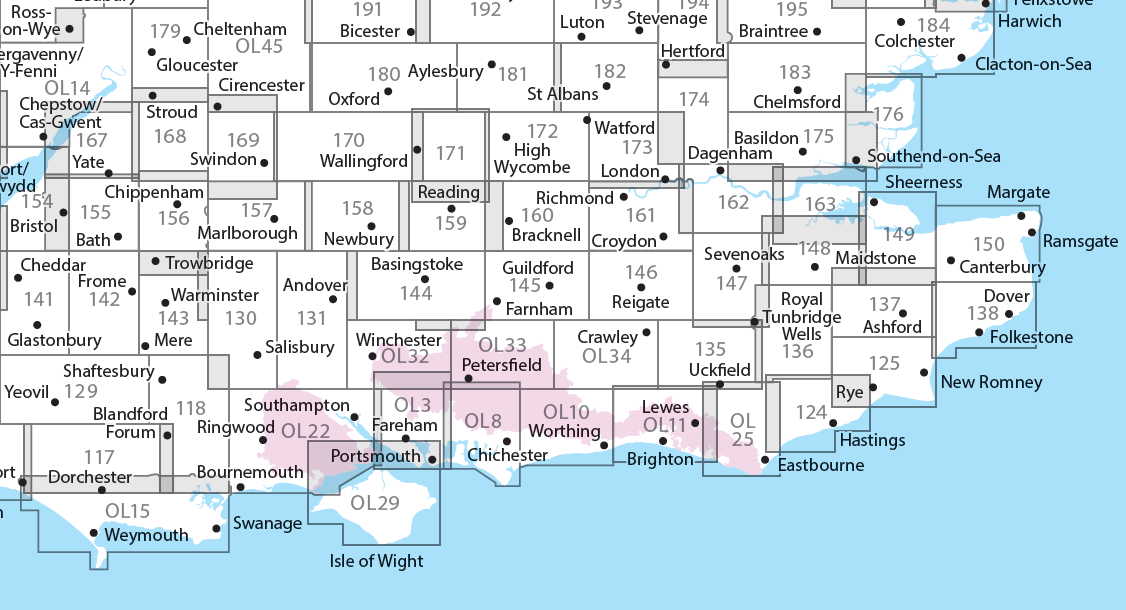
Producten op deze overzichtskaart:
Klik op een product om naar de pagina van dat product te gaan.
- Wandelkaart - Topografische kaart 117 OS Explorer Map Cerne Abbas & Bere Regis | Ordnance Survey
- Wandelkaart - Topografische kaart 118 OS Explorer Map Shaftesbury & Cranborne Chase | Ordnance Survey
- Wandelkaart - Topografische kaart 129 OS Explorer Map Yeovil & Sherborne | Ordnance Survey
- Wandelkaart - Topografische kaart 130 OS Explorer Map Salisbury & Stonehenge | Ordnance Survey
- Wandelkaart - Topografische kaart 131 OS Explorer Map Romsey, Andover & Test Valley | Ordnance Survey
- Wandelkaart - Topografische kaart 135 OS Explorer Map Ashdown Forest (greenw) | Ordnance Survey
- Wandelkaart - Topografische kaart 141 OS Explorer Map Cheddar Gorge, Mendip Hills West | Ordnance Survey
- Wandelkaart - Topografische kaart 142 OS Explorer Map Shepton Mallet , Mendip Hills East | Ordnance Survey
- Wandelkaart - Topografische kaart 143 OS Explorer Map Warminster, Trowbridge | Ordnance Survey
- Wandelkaart - Topografische kaart 144 OS Explorer Map Basingstoke, Alto, Whitchurch | Ordnance Survey
- Wandelkaart - Topografische kaart 145 OS Explorer Map Guildford, Farnham | Ordnance Survey
- Wandelkaart - Topografische kaart 146 OS Explorer Map Dorking, Box Hill, Reigate | Ordnance Survey
- Wandelkaart - Topografische kaart 147 OS Explorer Map Sevenoaks and Tonbridge | Ordnance Survey
- Wandelkaart - Topografische kaart 154 OS Explorer Map Bristol West, Portishead | Ordnance Survey
- Wandelkaart - Topografische kaart 155 OS Explorer Map Bristol, Bath | Ordnance Survey
- Wandelkaart - Topografische kaart 156 OS Explorer Map Chippenham, Bradford-on-Avon | Ordnance Survey
- Wandelkaart - Topografische kaart 157 OS Explorer Map Marlborough, Savernake Forest | Ordnance Survey
- Wandelkaart - Topografische kaart 158 OS Explorer Map Newbury, Hungerford | Ordnance Survey
- Wandelkaart - Topografische kaart 159 OS Explorer Map Reading, Wokingham & Pangbourne Map | Thames Path | Ordnance Survey
- Wandelkaart - Topografische kaart 160 OS Explorer Map Windsor, Weybridge, Bracknell | Thames Path | Ordnance Survey
- Wandelkaart - Topografische kaart 161 OS Explorer Map London South (greenw.m) | Ordnance Survey
- Wandelkaart - Topografische kaart 162 OS Explorer Map Greenwich, Gravesend | Ordnance Survey
- Wandelkaart - Topografische kaart 167 OS Explorer Map Thornbury, Dursley, Yate | Ordnance Survey
- Wandelkaart - Topografische kaart 168 OS Explorer Map Stroud, Tetbury, Malmesbury | Ordnance Survey
- Wandelkaart - Topografische kaart 169 OS Explorer Map Cirencester, Swindon | Ordnance Survey
- Wandelkaart - Topografische kaart 170 OS Explorer Map Abingdon, Wantage & Vale of White Horse | Ordnance Survey
- Wandelkaart - Topografische kaart 171 OS Explorer Map Chiltern Hills West | Ordnance Survey
- Wandelkaart - Topografische kaart 172 OS Explorer Map Chiltern Hills East | Ordnance Survey
- Wandelkaart - Topografische kaart 173 OS Explorer Map London North | Ordnance Survey
- Wandelkaart - Topografische kaart 174 OS Explorer Map Epping Forest, Lee Valley | Ordnance Survey
- Wandelkaart - Topografische kaart 179 OS Explorer Map Gloucester, Cheltenham, Stroud | Ordnance Survey
- Wandelkaart - Topografische kaart 180 OS Explorer Map Oxford | Ordnance Survey
- Wandelkaart - Topografische kaart 182 OS Explorer Map St-Albans, Hatfield | Ordnance Survey
- Wandelkaart - Topografische kaart OL03 OS Explorer Map Meon Valley - Portsmouth, Gosport & Fareham | Ordnance Survey
- Wandelkaart - Topografische kaart OL08 OS Explorer Map Chichester, South Harting & Selsey | Ordnance Survey
- Wandelkaart - Topografische kaart OL10 OS Explorer Map Arundel - Pulborough - Worthing | Ordnance Survey
- Wandelkaart - Topografische kaart OL11 OS Explorer Map Brighton & Hove, Lewes & Burgess Hill | Ordnance Survey
- Wandelkaart - Topografische kaart OL14 OS Explorer Map Wye Valley - Forest of Dean - Dyfryn Gwy | Ordnance Survey
- Wandelkaart - Topografische kaart OL15 OS Explorer Map Purbeck and South Dorset | Ordnance Survey
- Wandelkaart - Topografische kaart OL25 OS Explorer Map Eastbourne & Beachy Head | Ordnance Survey
- Wandelkaart - Topografische kaart OL29 OS Explorer Map Isle of Wight | Ordnance Survey
- Wandelkaart - Topografische kaart OL32 OS Explorer Map Winchester | Ordnance Survey
- Wandelkaart - Topografische kaart OL33 OS Explorer Map Haslemere & Petersfield | Ordnance Survey
- Wandelkaart - Topografische kaart OL34 OS Explorer Map Crawley & Horsham | Ordnance Survey
Overzichtskaarten
Beschrijving
Een van de beste detailkaarten die er op de wereld gemaakt worden: zeer gedetailleerd, prachtig helder kleurgebruik, veel topografische aspecten en - zeer belangrijk - allerlei toeristische en recreatieve aspecten zijn ingetekend. De perfecte kaart voor vakantie en vrije tijd: wandelen, fietsen of gewoon de omgeving verkennen. Door de grootte van de kaart, voor- en achterzijde,
bestrijkt het een behoorlijk groot gebied!
These highly detailed maps show all the administrative boundaries, settlements as small as isolated farms, road network down to unfenced roads and country tracks, and field boundaries (hedges and drystone walls) which make navigation across the countryside much easier. Steep gradients on roads are indicated. Various landmarks, eg. powerlines, archaeological sites, windmills, churches and lighthouses are shown, and additional graphics indicate natural terrain features such as cliffs, scree, mud and vegetation variations. Contour interval is 5 metres in the lower parts of the country and 10 metres in the uplands, and spot heights are marked. Each map covers an area of 30 x 20km (i.e. approx. 19 x 12 miles), with some double-sided maps covering more, as indicated in the individual descriptions. The maps are fully GPS compatible, with the National Grid shown at 1km intervals and latitude and longitude indicated by margin ticks at 1'.
Explorer maps show a large amount of information for ramblers and tourists. Public rights of way are shown (except in Scotland), together with other routes with public access: National Trails and Recreational Paths, permitted paths and bridleways, and selected cycle routes. Open access land created under the Countryside and Rights of Way Act 2000 is marked. Tourist information includes caravan and camp sites, Park & Ride locations, recreation/leisure/sport centres, museums, historic buildings, English Heritage and National Trust sites, rural pubs, etc. The map legend is in English only, except for the tourist information content which is also in French and German.
Reviews
Net terug van vakantie in Engeland vraagt u mij wat ik van de bij u aangekochte wandelkaarten vind. Wel, dat was niet de eerste keer dat ik bij u wat Topografische kaarten kocht en het zal, denk ik, ook niet de laatste keer zijn. Wat eigenlijk al aangeeft dat ik niet teleurgesteld ben in het gebruik van deze kaarten. Integendeel, ze zijn wederom zeer bruikbaar gebleken bij onze wandelingen. Daar waar borden langs de routes waren verdwenen konden wij m.b.v. de kaart welgemoed onze wandeling voortzetten. Verder vind ik de service van `de Zwerver` prima in vermelding en bevestiging van een bestelling en ook in de afhandeling van aankoop.
★★★★★ door Maarten Willers 18 oktober 2013Vond u dit een nuttige review? (login om te beoordelen)
Schrijf een review
Graag horen wij wat u van dit artikel vindt. Vindt u het goed, leuk, mooi, slecht, lelijk, onbruikbaar of erg handig: schrijf gerust alles op! Het is niet alleen leuk om te doen maar u informeert andere klanten er ook nog mee!

