Mandje Tel: +31503126950 Menu
Winkelwagen
Geen items in winkelwagen
Ga naar winkelwagen

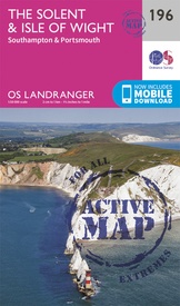
Wandelkaart - Topografische kaart 196 Landranger Active The Solent / the Isle of Wight | Ordnance Survey (9780319475195)

Southhampton, Portsmouth, Totton, Lymington, Fareham, Gosport, Cadnam, Lyndhurst, Brockenhurst, Hythe, Beaulieu, Calshot, East, Boldre, Netley, Warsash, Botley, Wickham, Hambledon, Southwick, Cowes, N

  • ISBN / CODE: 9780319475195
  • Editie: 24-02-2016
  • Aantal blz.: 1
  • Schaal: 1:50000
  • Uitgever: Ordnance Survey
  • Soort: Topografische kaart, Wandelkaart
  • Serie: Landranger Active
  • Taal: Engels
  • Hoogte: 23.0 cm
  • Breedte: 13.0 cm
  • Gewicht: 162.0 g
  • Uitvoering: Scheur- en watervast
  • Bindwijze: -
  • Schrijf als eerste een review
  • 25,95

    Leverbaar in 3 - 5 werkdagen in huis in Belgie Levertijd Nederland Leverbaar in 3 - 5 werkdagen in huis in Nederland Levertijd Belgie

    Gratis verzending in Nederland vanaf €35,-

Beschrijving

Explore the sandy beaches, historic houses and distinctive ‘chines’ of the Isle of Wight and soak up the beauty and tranquillity that made it a favourite with the likes of Queen Victoria and Alfred Lord Tennyson. Discover the vibrant maritime cities of Southampton and Portsmouth.
Visit the Mayflower Pilgrims’ Memorial, Portsmouth Historic Dockyard and the must-see Mary Rose
See royal Osborne House in East Cowes, imposing Carisbrooke Castle and the iconic Needles with unrivalled views of the Solent
Walk, hike and cycle along the Solent Way and other popular recreational paths 
 
Zeer goede detailkaart met topografische ondergrond. Kleurgebruik is goed over nagedacht: bijzonder goed leesbaar en helder kaartbeeld. Hierop zijn toeristische symbolen van bezienswaardigheden ingetekend, daarnaast staan bijvoorbeeld campings en jeugdherbergen vermeld en - voor wandelaars het belangrijkst - alle right of way paden en Lange afstands Wandelpaden zijn er op te vinden. De ideale kaart voor het wandelen in Engeland, Wales of Schotland. De kaarten zijn te gebruiken met GPS (UTM OSGB36), de legenda is in het Engels, Frans en Duits. 
 
Plaatsen op deze kaart: Southhampton, Portsmouth, Totton, Lymington, Fareham, Gosport, Cadnam, Lyndhurst, Brockenhurst, Hythe, Beaulieu, Calshot, East, Boldre, Netley, Warsash, Botley, Wickham, Hambledon, Southwick, Cowes, Newport, Ryde, Sandown, Shanklin, Ventnor, Godshill, Blackgang, Brighstone, Shalfleet, Yarmouth, the Needles.

Reviews

Geen reviews gevonden voor dit product.

Schrijf een review

Graag horen wij wat u van dit artikel vindt. Vindt u het goed, leuk, mooi, slecht, lelijk, onbruikbaar of erg handig: schrijf gerust alles op! Het is niet alleen leuk om te doen maar u informeert andere klanten er ook nog mee!