Categorieën
- Boeken
-
Kaarten
- Camperkaarten
- Educatieve kaarten
- Fietskaarten
- Fietsknooppuntenkaarten
- Historische Kaarten
- Pelgrimsroutes (kaarten)
- Spoorwegenkaarten
- Stadsplattegronden
- Toerskikaarten
- Topografische kaarten
- Wandelatlassen
- Wandelkaarten
- Wandelknooppuntenkaarten
- Waterkaarten
- Wegenatlassen
-
Wegenkaarten
- Afrika
- Azië
-
Europa
- Albanië
- Andorra
- Armenië
- Azerbeidzjan
- Belarus - Witrusland
- België
- Bosnië - Hercegovina
- Bulgarije
- Cyprus
- Denemarken
- Duitsland
-
Engeland
- North East England
- ♦ Northumberland National Park
- Yorkshire and the Humber
- ♦ Yorkshire Dales Nationaal Park
- ♦ North York Moors Nationaal Park
- North West England
- ♦ Lake District Nationaal Park
- ♦ North Pennines AONB
- 🥾 Hadrian's Wall Path
- East Midlands
- West Midlands
- ♦ Peak District Nationaal Park
- Wales
- ♦ Pembrokeshire Coast National Park
- ♦ Snowdonia Nationaal Park
- ♦ Brecon Beacons Nationaal Park
- East of England - East Anglia
- South West England
- Dorset
- ♦ Cotswolds AONB
- ♦ Devon - Cornwall
- 🥾 South West Coast Path
- ♦ New Forrest National Park
- ♦ Dartmoor National Park
- ■ Bristol
- South East England
- ♦ Kent
- ♦ South Downs Nationaal Park
- ♦ Isle of Wight
- ■ Londen
- ■ Oxford
- Kanaaleilanden
- ♦ Guernsey
- ♦ Jersey
- Estland
- Faroer
- Finland
- Frankrijk
- Georgië
- Griekenland
- Groenland
- Hongarije
- IJsland
- Ierland
- Italië
- Kosovo
- Kroatië
- Letland
- Liechtenstein
- Litouwen
- Luxemburg
- Malta
- Moldavië
- Monaco
- Montenegro
- Nederland
- Noord-Ierland
- Noord-Macedonië
- Noorwegen
- Oekraïne
- Oostenrijk
- Polen
- Portugal
- Roemenië
- Rusland
- Scandinavië
- Schotland
- Servië
- Slovenië
- Slowakije
- Spanje
- Tsjechië
- Turkije
- Vaticaanstad
- Zweden
- Zwitserland
- Midden-Amerika
- Midden-Oosten
- Noord-Amerika
- Oceanië
- Wereld
- Zuid-Amerika
- Wintersportkaarten
- Opruiming
- Puzzels
- Travel Gadgets
- Wandkaarten
- Wereldbollen
Veilig online betalen
Betaal veilig via uw eigen bankomgeving
- U bent hier:
- Home
- Europa
- Engeland
- ♦ Cotswolds AONB
- Kaarten
- Wegenkaarten
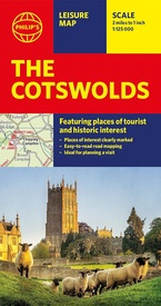
Wegenkaart - landkaart The Cotswolds | Philip's Maps (9781849075381)
leisure map
- ISBN / CODE: 9781849075381
- Schaal: 1:125000
- Auteur(s): Philip's Maps
- Uitgever: Philip's Maps
- Soort: Wegenkaart
- Taal: Engels
- Bindwijze: -
- Uitvoering: Papier
- Schrijf als eerste een review
-
€ 11,50
Op voorraad. Binnen 2 - 3 werkdagen in huis in Belgie Levertijd Nederland Voor 17.00 uur op werkdagen besteld, morgen in huis in Nederland Levertijd Belgie
Gratis verzending in Nederland vanaf €35,-
- Afbeeldingen
- Inkijkexemplaar
Beschrijving
A new edition of this double-sided map of the Cotswolds clearly featuring places of tourist and historic interest in an easy-to-read style of mapping, alongside six handy town centre plans.
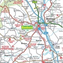
This leisure and tourist map of the Cotswolds gives detailed coverage of the area's road network at a scale of approximately 2 miles to 1 inch (1:125,000). The coverage stretches from Abingdon in the east to Gloucester in the west, and from Swindon in the south to Great Malvern in the north.
The map shows places of tourist and historic interest, including castles, camping and caravanning sites, country parks, galleries, gardens, golf courses, museums, nature trails, historic sites, sports venues, theatres and wildlife parks. An index to principal places of interest is also featured.
With some of the most enchanting towns and cities in England in the area - all with extraordinary history and notable natural beauty - use the Philip's Leisure Map to explore and delight in the Cotswold magic. Included in the mapping are indexed town-centre street maps for Bourton-on-the-Water, Cheltenham, Cirencester, Gloucester, Tewkesbury and Winchcombe for easy navigation and enjoyment.
In a convenient folded format, this double-sided sheet map is ideally suited for both leisure and business use, whether by locals or visitors.
Reviews
Geen reviews gevonden voor dit product.
Schrijf een review
Graag horen wij wat u van dit artikel vindt. Vindt u het goed, leuk, mooi, slecht, lelijk, onbruikbaar of erg handig: schrijf gerust alles op! Het is niet alleen leuk om te doen maar u informeert andere klanten er ook nog mee!
Ook interessant voor europa/engeland/cotswolds
-

Fietskaart 02 Cycling guides Cotswol
€ 15,95Fietskaarten ♦ Cotswolds AONB -

Wegenkaart - landkaart Cotswolds map
€ 15,95Wegenkaarten ♦ Cotswolds AONB -

Wandelkaart Walking the Cotswold Way
€ 13,95Wandelkaarten ♦ Cotswolds AONB -

Reisgids Cotswolds | Rough Guides
€ 12,95Reisgidsen ♦ Cotswolds AONB -

Wandelgids The Cotswold Way | Aurum
€ 20,95Wandelgidsen ♦ Cotswolds AONB


